

Scan Survey is one of the first companies in the world to both own and operate the mobile mapping system Leica Pegasus:Backpack. The system is a sensor platform used to collect and georeference laser data and images. In principle the Leica Pegasus:Backpack works as a traditional mobile mapping system, (similarly to vehicle scanning), where the sensor platform dynamically collects data (while moving) and positions with the use of GNSS (GPS and GLONASS), IMU (inertial navigation) and SLAM (Simultaneous Localization and Mapping). This allows the system to be used in areas without GNSS coverage, such as dense forests and indoor situations, while still receiving georeferenced data with documented accuracy. The system can also utilize traditional benchmarks for georeferencing. We can cater our service for any of your needs and can produce detailed pointclouds, terrain and 3D models.
Among the First

 The Leica Pegasus:Two mobile mapping vehicle
The Leica Pegasus:Backpack has several obvious advantages. The system is mobile; the complete system weighs a mere total of 13 kg. This makes it easy to move through terrain, in addition to being quick and cost effective to mobilize over larger areas. The system is extremely well suited for mapping, documentation, and registration for railways, walls, constructions, and BIM-projects.
The result of these scans are georeferenced, colored point clouds which are processed and quality checked prior to the data being used to generate a 3D-model. In addition, images are taken with the integrated system cameras which themselves are calibrated with the laser scanners. Both images and point clouds are thus synchronized, and can be utilized together in advanced GIS-tools.

Scan Survey AS offers a wide spectrum of mapping, measuring, GIS, and 360-street views from our mobile mapping equipment. Our range of equipment includes both the backpack and a unit normally mounted on a vehicle, though the unit can easily be mounted on a boat, subway, ATV, transport bike, etc. Data collection can be mobilized in a short amount of time, it’s efficient in the field, and the need for prior notice and traffic safety measures are minimal.
Typical projects include tunnels, construction sites, city streets, railways, highways, buildings, and parks. Delivery methods includes point clouds, detailed measurements, terrain models, 360-images, thermographics, GIS-databases, and NVDB. All the aforementioned products can be delivered from a point data collection. Our clients include designing consultants, construction clients, municipalities, contractors, architects, and landscape architects.
Would you like to know more? Contact our Head of Department!
Terrain Models and Detailed Measurements
Scan Survey AS has extensive experience producing manageable TIN-models from sources such as mobile mapping, terrestrial scanning, airborne scanning, RPAS (drone), as well as traditional field surveying. All these various data sources can be sewed together into a single model.
From point clouds and 360-images we’re able to digitize all objects of interest within the project area. This includes both details on a surface or façade and points with metadata, which are then transferred to a GIS-database or NVDB.

Tunnel Measuring
Mobile mapping is an efficient method for the laser scanning of tunnels; both large tunnels in which we can utilize our vehicle, and smaller tunnels whereupon the backpack can be utilized. Mobile mapping gives excellent coverage of all objects, an even point density over the entire tunnel profile, and has thousands of points per square meter to ensure that even the smallest object is appropriately measured.
360-images
360-degree image bubbles, like those found in Google’s Street View, deliver an intuitive view in one’s browser where installation of a 3rd party program proves entirely unnecessary.
Data deliveries include point clouds, tunnel profiles, TIN-models, detailed measurements, and 360-degree image bubbles. Utilizing thermography, we’re able to detect tunnel leakages and the overheating of electrical components.
360-degree images can be taken in environments where on would suspect subpar image quality, like dark tunnels.

Overheating in Electrical Components
Overheating in, for example, distribution cabinets or other electrical components, and leakage in tunnels can be detected by means of thermography.
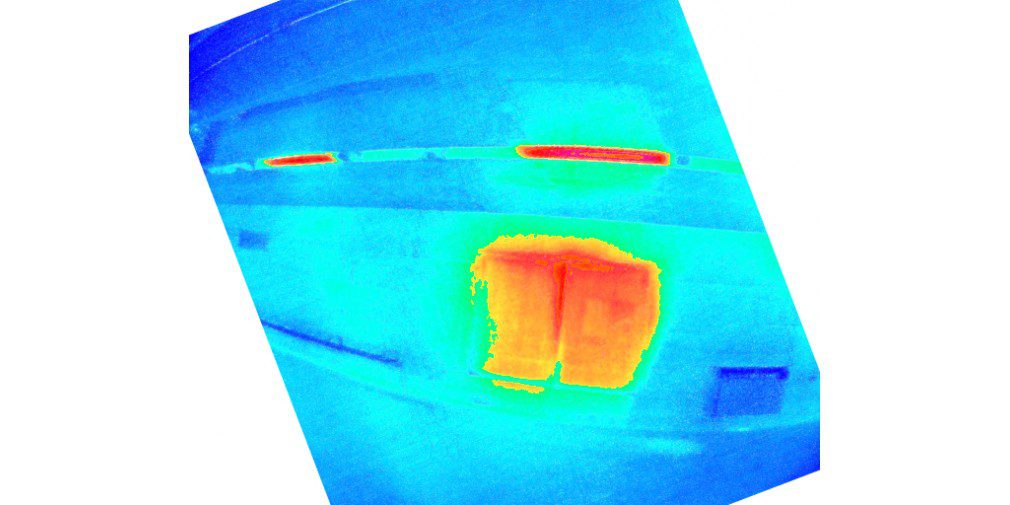
A warm electrical cabinet in a tunnel lights up on thermal cameras
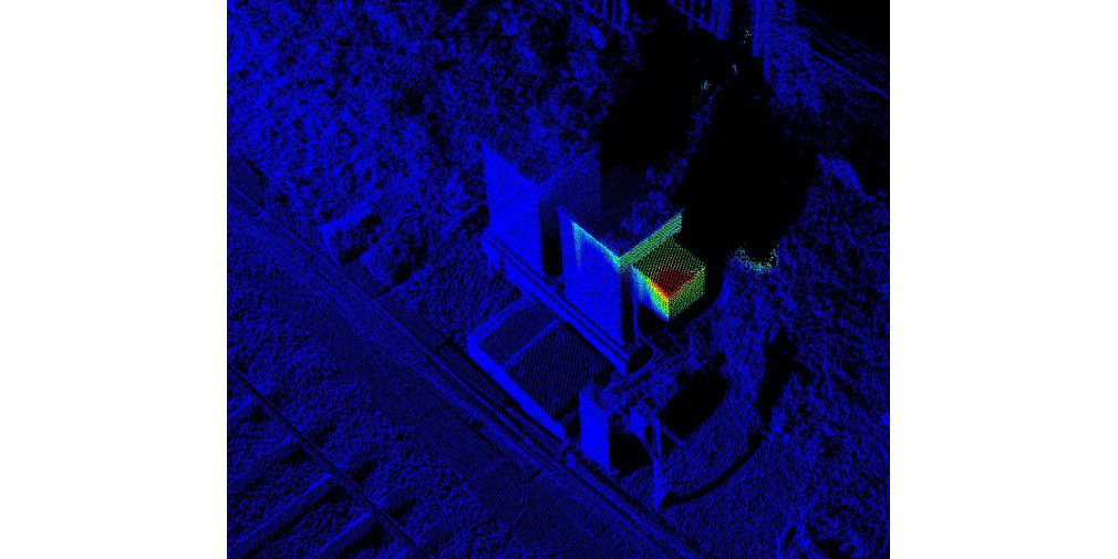
A warm electrical cabinet in a tunnel lights up on thermal cameras
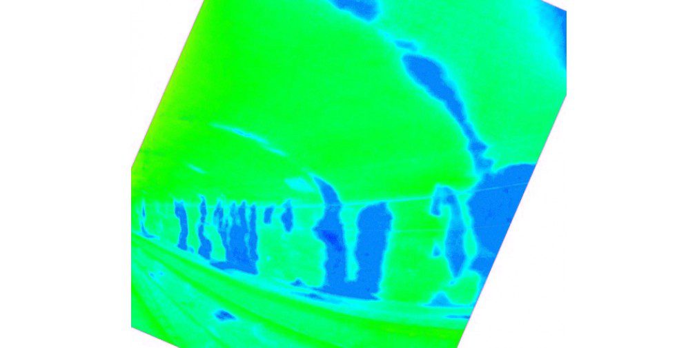
Moist areas in a tunnel stand out as blue in the image
GIS-Database and NVDB
Detailed measurements and 360-degree images could form the basis of a GIS-database or NVDB. One example of a detailed measurement could be a lamp post. Metadata, like diameter, height, slope, and material, could be attached to the lamp post. A direct link from the database object to a connecting image can also be added.

Analysis of Asphalt Quality
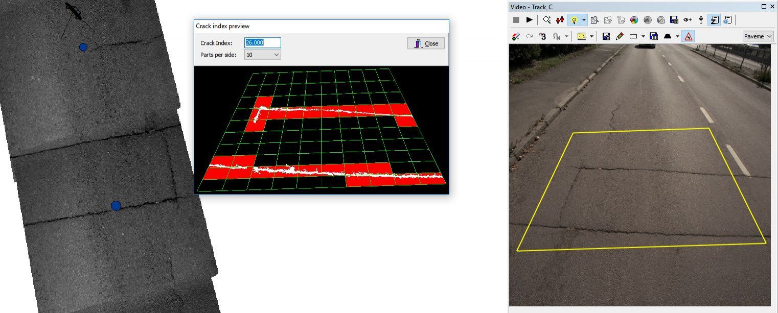
Longitudinal irregularity (IRI), cross-sectionality (tracking depth), where cracks in the asphalt cover appear, and orthophotos of lanes are among the parameters that can be analyzed.
Management, Operation and Maintenance of Roads
Asphalt analysis, GIS databases, and 360-images are methods to document road condition at a specific moment in time. A new data set and calculations at a later point in time can reveal changes.
Examples include asphalt wear and where the wear is worst, if cracks in the tarmac appear in an area, or if there has been construction activity in an area.
Periodic Project Documentation
Periodic documentation and measurement during the construction process are performed in an efficient fashion. Mobile data collection minimizes interruptions in system operation, and accurate data is available within a short time period.
Equipment
Back in 2017, Scan Survey was the first company in Norway to perform mobile mapping from both a backpack and vehicle-based platforms. Both instruments are manufactured by Leica, which offers a number of advantages in the production process.
The Leica Pegasus backpack: Backpack is easy to mobilize, and we can easily get to areas where vehicles cannot reach or gain access. In park areas and along with the subways and railways, we have greatly enjoyed the backpack.
We usually use the vehicle-based platform Leica Pegasus: Two on a car, but it is also easy to move to a boat, ATV, tram, transport bike or similar. With this instrument, we perform data collection over large distances in a short time, without coming into conflict with other traffic or other ongoing activities in the project area.
Specific needs and equipment complement each other well. With mobile mapping, time in the field is reduced. HSE is also an important aspect, as the surveyor does not have to stay on the road.
In the spring of 2022, we worked systematically to integrate laser data from drone mapping together with data sets from cars, backpacks and terrestrial laser scanning. In the past, with car-borne laser scanning (Mobile Mapping), it has been possible to experience a lack of coverage where the topography or physical objects prevent access from the road surface. We are now solving this with drone mapping. The drone now ensures good coverage in side terrain and behind hedges, walls, and noise walls, in a way that has not previously been possible.


What We Deliver
Scan Survey AS has extensive experience delivering products to project consultants, construction clients in the public sector, contractors, architects, landscape architects, etc. We deliver data ready for import in all file formats, whether the tool is NovaPoint, Revit, ReCap, Gemini, Focus or other GIS- and BIM-tools. Typical file formats include IFC, DWG, LandXML, SOSI, TIT/NYL, LAS and LAZ. Contact Halvor Vadder if you have questions about our Mobile Mapping services!